
Trace a Fountain Hills Street
A reliable street search is map-first. One Fountain Hills address can lead to the current tax parcel, the recorded subdivision, nearby parcel numbers, and the deed that placed the named owner in the chain. Ownership is public evidence. Occupancy is a different question. A mailing address that matches the property may support owner occupancy, yet it does not identify every resident. A different mailing address may belong to a trust, estate, seasonal owner, or business.
Use the same facts at every stage. Keep the exact situs address, assessor parcel number, subdivision or MCR map number, deed number, and retrieval date. MCR is the county map-record reference attached to a recorded subdivision. This set of identifiers protects the address search from spelling changes and similar street names.
- Enter the standardized address in the Maricopa County Assessor search. Record the APN, situs address, owner name, mailing address, subdivision, legal description, and linked deed number.
- Open the county Parcel Viewer. Confirm the parcel shape and select only the street segment or lots needed.
- Follow each deed number into the Recorder's Recorded Document Search. Compare party roles and legal descriptions rather than relying on a name alone.
- Request a town permit or code file by exact address and date range when construction history matters.
- Use voter data only through the lawful request channels. For older occupants, consult a regional directory or released census record instead of assuming the current owner lived there.
Search the Fountain Hills Street Directory
The Maricopa County Assessor search instructions document several ways to find a Fountain Hills parcel. A full address is useful, but it is not the only key. Search can begin with the APN in dashed or compact form, an owner name, subdivision or MCR, city, ZIP, section-township-range, business account, or mobile-home details. Owner names work best when the first name is not shortened.
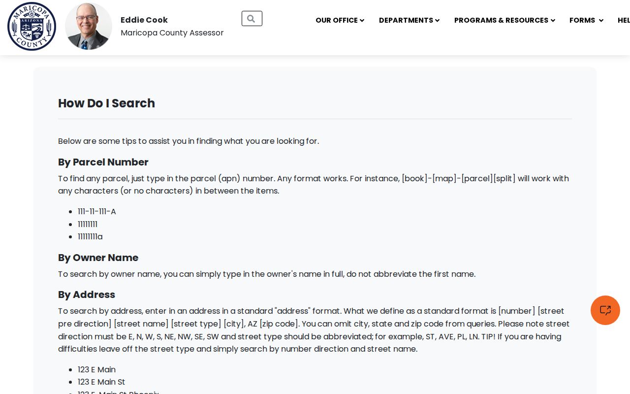
The captured assessor instructions make the street directory reproducible when a typed address fails. Try the house number, direction, and street without extra punctuation, then move to subdivision or APN. A parcel result can show the current owner, tax mailing destination, situs address, deed number and date, subdivision, lot data, values, improvements, and map links. Save only the facts needed for the research task.
| Search Key | Accepted Form | Best Street Use |
|---|---|---|
| Address | Standardized street address; city and ZIP optional | Find one known parcel |
| APN | Dashed or compact parcel number | Reopen an exact parcel |
| Owner | Full first and last name | Check another indexed parcel |
| Subdivision or MCR | Recorded name or map reference | Group platted lots |
| City or ZIP | Fountain Hills or 85268 | Start broad, then narrow |
| Land grid | Section, township, and range | Locate edge or older tracts |
Note: The assessor's mailing address is for tax correspondence, while the situs address identifies the physical land being assessed.
Map Fountain Hills Streets in GIS
The county Parcel Viewer turns a single result into a street-by-street browse. Its “What I Know” search accepts APN, owner, subdivision, MCR, section-township-range, ZIP, Map ID, and personal-property account. Map selection can use Point, Line, Polyline, Extent, Circle, Polygon, or Freehand Polygon. A buffer may be placed around the shape, and Create, Add, or Remove controls refine the result set.
The official GIS search help illustrates those shape and buffer controls.
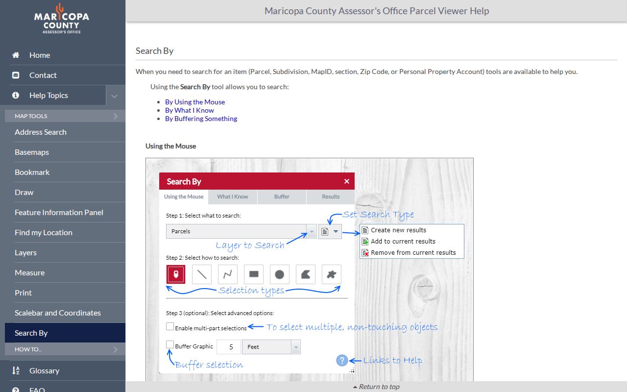
That interface is most useful after zooming to a short Fountain Hills street segment. A citywide or ZIP-wide query can reach the 1,000-feature display cap. Draw a line down the street and apply a modest buffer, or use a polygon around the desired lots. Clicking a result zooms to it and fills the Feature Information panel. The parcel outline is informative, not a legal survey.
Compare Fountain Hills Street Records
No single roll is a complete Fountain Hills street directory. The assessor is strongest for present ownership. GIS supplies the spatial link between lots. Recorder instruments document transfers and land restrictions. Town files can date work at a site. Voter material is purpose-limited and cannot be treated as a public browse-by-street list. Historical directories help only when a regional volume actually covers the place and year.
| Address Source | Custodian | Street Evidence | Access Route |
|---|---|---|---|
| Parcel roll | Maricopa County Assessor | Owner, situs, mailing address, APN, deed link | Free online search |
| Parcel GIS | Maricopa County Assessor | Lot shape, adjacency, subdivision, ZIP context | Free viewer |
| Recorded documents | Maricopa County Recorder | Transfers, plats, liens, CC&Rs, affidavits | Free index and unofficial images; paid official copies |
| Permits and code files | Fountain Hills Town Clerk | Project applicant, owner, contractor, inspection dates | Online request, then clerk routing |
| Voter files | Maricopa County Recorder | Permitted registration and participation fields | Online or PDF request, email, fax, or appointment |
| Regional directories | State Library and partners | Occupant by address where a street section exists | Digital search, Reading Room, or remote request |
These sources describe different relationships to the same place. A deed party may be a grantor, trustee, borrower, or beneficiary rather than a resident. A permit applicant may appear for one project. A directory entry is dated to its edition. The record trail works only when each role and date remains attached to its source.
Follow Fountain Hills Streets Into Deeds
The Maricopa County Recorded Document Search accepts modern recording numbers, older docket or book and page references, business names, person names, document codes, map book and page, and date ranges. Its separate full-text Research field covers the latest two years and can search names, legal descriptions, or addresses with exact phrases and Boolean terms. The structured party and document searches remain essential outside that recent window.
Open the deed number supplied by the assessor. Check the grantor, grantee, recording date, document title, and legal description. A deed image may include conveyance terms, and an attached affidavit of property value may show a sale price when it was filed and not exempt. Search a subdivision or association in Business Name to locate plats and CC&Rs. The Recorder's document-code list helps distinguish a deed from a deed of trust, release, easement, or notice. The Recorder guidance explains copies, plats, covenants, and sale-price limits.
Record limit. A Recorder search is not a title report and cannot establish that no lien exists; the office advises a professional title search for that conclusion.
Unofficial images are available for reading. Official copies cost $1 per page, with $3 added per certified document. Buying options include email download or physical mail. Counter help remains important for a hard-to-read index, a legacy book and page, or a parcel whose identifier changed.
Decode Fountain Hills Street Records
Address research becomes clearer once the land terms stay separate. Fountain Hills was developed through plats and subdivisions, so the durable land description often matters more than the words on a mailbox. These definitions also prevent a tax mailing address from being reported as a home address.
- Parcel
- A tract carried on the assessor roll under an APN, or assessor parcel number. Splits and combinations can create a new APN.
- Situs address
- The physical location assigned to the taxable land or improvement. It is not proof of every person who lives there.
- Legal description
- The formal land identity, such as subdivision, lot, block, map reference, or metes-and-bounds description.
- Plat
- A recorded map dividing land into lots, blocks, streets, easements, and other mapped features.
- Criss-cross directory
- A directory arranged by street and house number rather than by surname. No official Fountain Hills-specific run was verified.
Keep every old APN, subdivision spelling, lot and block, MCR number, and directional prefix in a research log. Those details reconnect a street address to recorded land when a parcel changes or the older instrument omits the modern address.
Refine Fountain Hills Streets by Subdivision
Fountain Hills development names are practical search keys. Eagle Mountain, Firerock, SunRidge Canyon, Lakeside Village, Bainbridge, Golden Eagle, and numbered Fountain Hills plats may appear in assessor, GIS, planning, or Recorder records. A subdivision hyperlink can enumerate its assessed parcels and expose the MCR reference. That is often more precise than searching all of Fountain Hills or all of ZIP code 85268.
A neighborhood label and a recorded subdivision are not always the same boundary. One familiar area may contain several plats, while a platted development may extend beyond the area a resident calls a neighborhood. Confirm each candidate lot in Parcel Viewer. Then consult its recorded plat for the legal lot and block layout. For a current address-by-address method, the dedicated Fountain Hills previous residents trail can carry one parcel backward through time.
Fountain Hills incorporated on December 5, 1989. Earlier land and planning evidence is therefore county-first. A present street name may not exist in pre-development instruments, while the legal description, township-range-section, or subdivision map may still connect the same land.
Request Fountain Hills Address Records
No stable public permit-search field set was verified for Fountain Hills. Use the Town Clerk public-record request portal when a permit card, application, plan, certificate of occupancy, inspection history, or code file is not exposed online. Give the exact address and APN, an approximate date range, the named record series, and the format desired. Arizona Public Records Law uses a prompt production standard rather than one fixed deadline for every request.
A permit can date construction or an alteration. It may name an owner, applicant, contractor, or contact at the time of the project. It does not prove a move date or every person in the household. Pre-incorporation planning and permit material may instead sit with Maricopa County because Fountain Hills was not yet a town.
- Address or parcel questions go to the Assessor.
- Recorded deed and plat questions go to the Recorder at 602-506-3535.
- Property-tax questions go to the Treasurer at 602-506-8511.
- Town permit, code, and planning files begin with the Fountain Hills Town Clerk.
Note: Ask for a named series and date range; a records clerk is not expected to research every person tied to an address.
Fountain Hills Street Voter Limits
The Arizona Voter Information Portal is an identity-gated self-service lookup, not an open Fountain Hills street directory. It may return registration status, address context, districts, party, ballot status, polling details, and participation. It never reveals ballot choices. A public voter-file route exists through the Recorder's voter and election request forms, but Arizona law limits permitted uses and internet redistribution.
Requests may be submitted through the online portal or a PDF by email or fax, with inspection available by appointment. An individual history request needs full name, date of birth, and last known address. Electronic delivery may use a password and a separate secure link that expires after two weeks. Protected voters are excluded under A.R.S. §16-153, while A.R.S. §16-168 controls access and use.
Registration is evidence at an effective date. It may change after a move or notice. It also misses people who are not registered, household members who are not listed in a deed, and people protected by law. Do not convert a bounded voter file into a claimed public list of everyone living along a Fountain Hills street.
Limits of the Fountain Hills Street Directory
Address-keyed public records cannot show real-time occupancy. The property roll omits non-owner occupants and most household members. Deeds can name trusts, estates, and entities. Utility customers and motor-vehicle addresses are not open street-directory fields. Protected government addresses may be removed or replaced. A regional directory may omit the town, a seasonal resident, or a newly built street.
Commercial compilations add their own risks. They may merge two people with the same name, retain old addresses, or repeat a public record after its source changes. Treat such material as a lead at most. Verify a needed fact with the assessor, Recorder, Town Clerk, or other actual custodian.
Lawful use. Fountain Hills address records are for lawful personal research, such as parcel history and civic curiosity. Never use them to stalk, harass, threaten, or intimidate anyone.
A careful Fountain Hills street directory therefore reports source, date, role, and limit together. “Named owner on the current parcel roll” is accurate. “Lives here now” often is not. That distinction protects both the person being researched and the reliability of the final address trail.